
The Chinese Laser Altimetry Satellite will significantly enhance the 3D mapping capability of global coastal zones
-

-
REFERENCES
[1] Murray N. J., Phinn S. R., DeWitt M. et al. (2019). The global distribution and trajectory of tidal flats. Nature 565:222−225. DOI:10.1038/s41586-018-0805-8 [2] Li P., Li Z., Dai K. et al. (2021). Reconstruction and evaluation of DEMs from bistatic Tandem-X SAR in mountainous and coastal areas of China. IEEE J. Sel. Top. Appl. Earth Observ. Remote Sens. 14:5152−5170. DOI:10.1109/JSTARS.2021.3073782 [3] Tang X. and Li G. (2019). Thoughts about Land and Sea Satellite Laser Altimetry. Aerosp. Shanghai 36:15−19. [4] Xie J., Liu R., Yang X. et al. (2023). On-orbit geometric calibration of satellite laser altimeters using infrared detectors and corner-cube retroreflectors. Int. J. Digit. Earth. 16:2067−2088. DOI:10.1080/17538947.2023.2220617 [5] Xu N., Ma Y., Yang J. et al. (2022). Deriving tidal flat topography using ICESat‐2 laser altimetry and sentinel‐2 imagery. Geophys. Res. Lett. 49:e2021GL096813. DOI:10.1029/2021GL096813 -
ABOUT THIS ARTICLE
Cite this article:
Yao J., Mo F., Xu N., et al. (2025). The Chinese Laser Altimetry Satellite will significantly enhance the 3D mapping capability of global coastal zones. The Innovation Geoscience 3:100121. https://doi.org/10.59717/j.xinn-geo.2024.100121
Welcome!
To request copyright permission to republish or share portions of our works, please visit Copyright Clearance Center's (CCC) Marketplace website at marketplace.copyright.com.
Export File
Citation
Yao J., Mo F., Xu N., et al. (2025). The Chinese Laser Altimetry Satellite will significantly enhance the 3D mapping capability of global coastal zones. The Innovation Geoscience 3:100121. https://doi.org/10.59717/j.xinn-geo.2024.100121

Format
Content
 DownLoad:
-
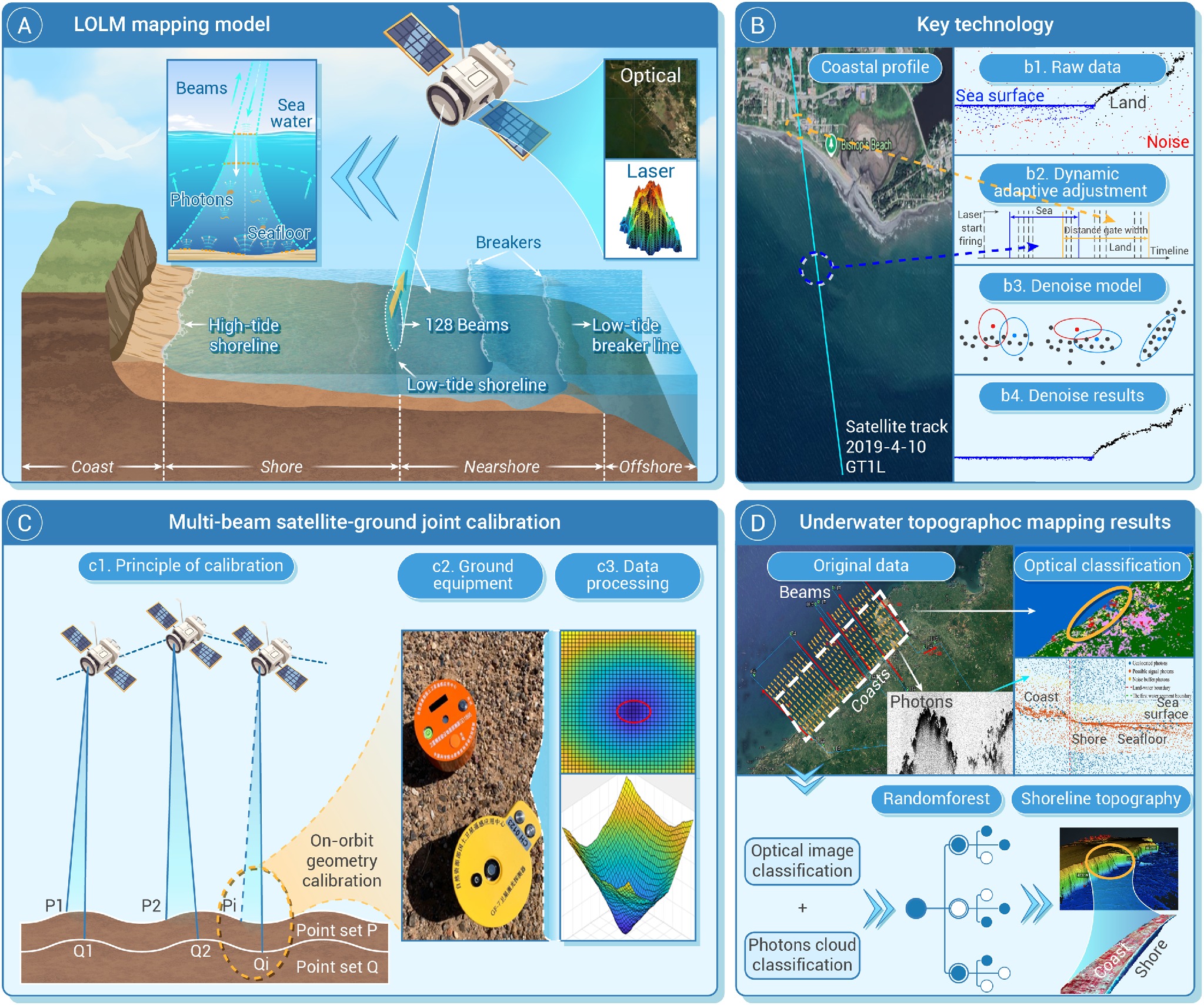
Figure 1.
Schematic diagram of land-ocean laser altimetry satellite mapping and applications
