
Grounded open-vocabulary 3D LiDAR AI for natural resource surveying
-

-
REFERENCES
[1] Wu K., Zhang Y., Ru L., et al. (2025). A semantic-enhanced multi-modal remote sensing foundation model for Earth observation. Nat. Mach. Intell. 7:1235−1249. DOI:10.1038/s42256-025-01078-8 [2] Maeda E.E., Brede B., Calders K., et al. (2025). Expanding forest research with terrestrial LiDAR technology. Nat. Commun. 16:8853. DOI:10.1038/s41467-025-63946-6 [3] Prümers H., Betancourt C.J., Iriarte J., et al. (2022). Lidar reveals pre-Hispanic low-density urbanism in the Bolivian Amazon. Nature 606:325−328. DOI:10.1038/s41586-022-04780-4 [4] Frachetti M.D., Berner J., Liu, X., et al. (2024). Large-scale medieval urbanism traced by UAV-lidar in highland Central Asia. Nature 634:1118−1124. DOI:10.1038/s41586-024-08086-5 [5] Chang Y., Zhang J., Ding Y., et al. (2025). Towards intelligent digital ecological civilization: The rise of geospatial foundation models. Innov. Inform. 2:100023. DOI:10.59717/j.xinn-inform.2026.100023 -
ABOUT THIS ARTICLE
Cite this article:
Xia A., Chen Y., Han T., et al. (2026). Grounded open-vocabulary 3D LiDAR AI for natural resource surveying. The Innovation Informatics 2:100057. https://doi.org/10.59717/j.xinn-inform.2026.100057
Welcome!
To request copyright permission to republish or share portions of our works, please visit Copyright Clearance Center's (CCC) Marketplace website at marketplace.copyright.com.
Export File
Citation
Xia A., Chen Y., Han T., et al. (2026). Grounded open-vocabulary 3D LiDAR AI for natural resource surveying. The Innovation Informatics 2:100057. https://doi.org/10.59717/j.xinn-inform.2026.100057

Format
Content
 DownLoad:
-
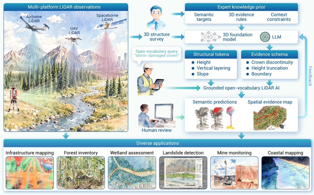
Figure 1.
Grounded open-vocabulary LiDAR Artificial Intelligence (AI) for natural resource surveying
