
Toward minute-level flood stereoscopic intelligence: Real-time multimodal remote sensing under an on-orbit AI paradigm
-

-
REFERENCES
[1] Misra A., White K., Nsutezo S.F., et al. (2025). Mapping global floods with 10 years of satellite radar data. Nat. Commun. 16:5762. DOI:10.1038/s41467-025-60973-1 [2] Bentivoglio R., Isufi E., Jonkman S.N., et al. (2022). Deep learning methods for flood mapping: A review of existing applications and future research directions. Hydrol. Earth Syst. Sci. 26:4345−4378. DOI:10.5194/hess-26-4345-2022 [3] Wang Q. (2022). Research framework of remote sensing monitoring and real-time diagnosis of earth surface anomalies. Acta Geod. Cartogr. Sin. 51:11. DOI:10.11947/j.AGCS.2022.20220124 [4] Li D., Wang M., Yang F., et al. (2023). Internet intelligent remote sensing scientific experimental satellite Luojia-3-01. Geo-spat. Inf. Sci. 26:257−261. DOI:10.1080/10095020.2023.2208472 [5] Yao J., Wang M., Xu N., et al. (2025). 3-D flood mapping from SWOT observations during extreme rainfall: A case study of Gangnan Reservoir. Int. J. Digit. Earth. 18:2544916. DOI:10.1080/17538947.2025.2544916 -
ABOUT THIS ARTICLE
Cite this article:
Yao J., Ma C., Wang M., et al. (2026). Toward minute-level flood stereoscopic intelligence: Real-time multimodal remote sensing under an on-orbit AI paradigm. The Innovation Informatics 2:100022. https://doi.org/10.59717/j.xinn-inform.2026.100022
Welcome!
To request copyright permission to republish or share portions of our works, please visit Copyright Clearance Center's (CCC) Marketplace website at marketplace.copyright.com.
Export File
Citation
Yao J., Ma C., Wang M., et al. (2026). Toward minute-level flood stereoscopic intelligence: Real-time multimodal remote sensing under an on-orbit AI paradigm. The Innovation Informatics 2:100022. https://doi.org/10.59717/j.xinn-inform.2026.100022

Format
Content
 DownLoad:
-
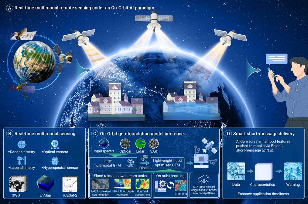
Figure 1.
A new paradigm of flood Stereoscopic intelligence via next-generation multimodal satellite remote sensing with on-orbit AI
