
Deforestation in Latin America in the 2000s predominantly occurred outside of typical mature forests
-
GRAPHICAL ABSTRACT
 DownLoad:
Full size image
DownLoad:
Full size image
-
PUBLIC SUMMARY
- ■ The accuracy of existing carbon density maps is limited owing to the lack of direct measures of vertical forest structures.
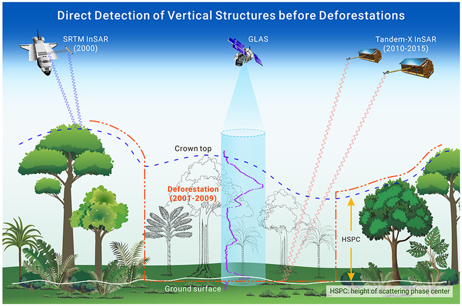
- ■ The synergy of interferometric synthetic aperture radar (InSAR) data acquired before and after deforestation has been proposed as a direct measure of vertical forest structures.
- ■ An accurate map of carbon density in the deforested areas was produced using light detection and ranging (lidar) data, forestloss maps, and vertical forest structures.
- ■ New results have revealed that carbon loss caused by deforestation in the 2000s in Latin America was severely overestimated.
- ■ Knowledge of the role of Latin American forests in the 2000s in global carbon budgets has been challenged by this new result.
-
ABSTRACT
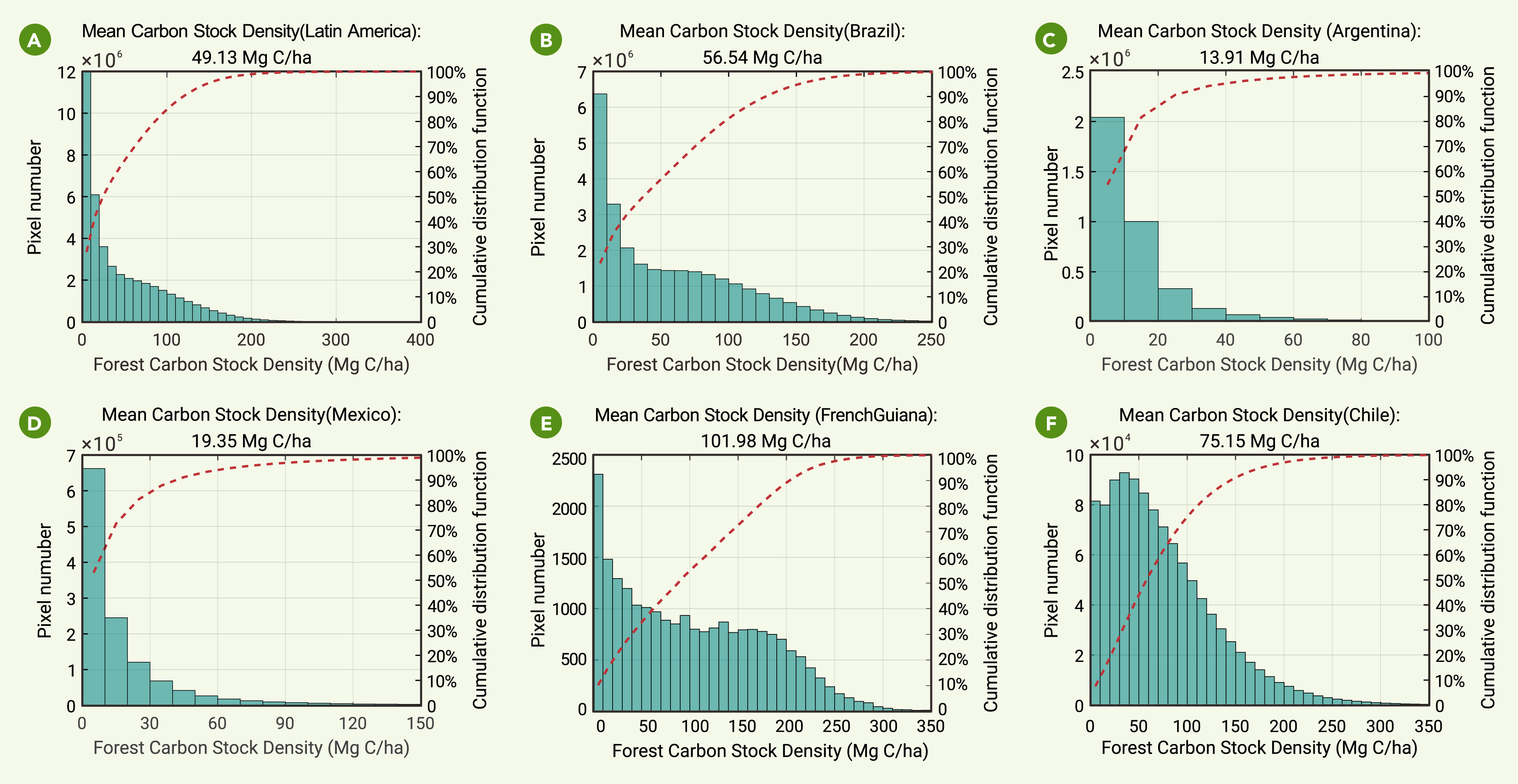
The role of tropical forests in the global carbon budget remains controversial, as carbon emissions from deforestation are highly uncertain. This high uncertainty arises from the use of either fixed forest carbon stock density or maps generated from satellite-based optical reflectance with limited sensitivity to biomass to generate accurate estimates of emissions from deforestation. New space missions aiming to accurately map the carbon stock density rely on direct measurements of the spatial structures of forests using lidar and radar. We found that lost forests are special cases, and their spatial structures can be directly measured by combining archived data acquired before and after deforestation by space missions principally aimed at measuring topography. Thus, using biomass mapping, we obtained new estimates of carbon loss from deforestation ahead of forthcoming space missions. Here, using a high-resolution map of forest loss and the synergy of radar and lidar to estimate the aboveground biomass density of forests, we found that deforestation in the 2000s in Latin America, one of the severely deforested regions, mainly occurred in forests with a significantly lower carbon stock density than typical mature forests. Deforestation areas with carbon stock densities lower than 20.0, 50.0, and 100.0 Mg C/ha accounted for 42.1%, 62.0%, and 83.3% of the entire deforested area, respectively. The average carbon stock density of lost forests was only 49.13 Mg C/ha, which challenges the current knowledge on the carbon stock density of lost forests (with a default value 100 Mg C/ha according to the Intergovernmental Panel on Climate Change Tier 1 estimates, or approximately 112 Mg C/ha used in other studies). This is demonstrated over both the entire region and the footprints of the spaceborne lidar. Consequently, our estimate of carbon loss from deforestation in Latin America in the 2000s was 253.0 ± 21.5 Tg C/year, which was considerably less than existing remote-sensing-based estimates, namely 400–600 Tg C/year. This indicates that forests in Latin America were most likely not a net carbon source in the 2000s compared to established carbon sinks. In previous studies, considerable effort has been devoted to rectify the underestimation of carbon sinks; thus, the overestimation of carbon emissions should be given sufficient consideration in global carbon budgets. Our results also provide solid evidence for the necessity of renewing knowledge on the role of tropical forests in the global carbon budget in the future using observations from new space missions. -

-
REFERENCES
[1] Friedlingstein, P., Jones, M.W., O’Sullivan, M., et al. (2019). Global Carbon Budget 2019. Earth Syst. Sci. Data 11: 1783–1838. https://doi.org/10.5194/essd-11-1783-2019. [2] Zhu, Y., Wang, D., Smith, P., et al. (2022). What can the Glasgow Declaration on Forests bring to global emission reduction? Innovation 3: 100307. https://doi.org/10.1016/j.xinn.2022.100307. [3] Hansen, M.C., Potapov, P.V., Moore, R., et al. (2013). High-Resolution Global Maps of 21st-Century Forest Cover Change. Science 342: 850–853. https://doi.org/10.1126/science.1244693. [4] Hong, C., Burney, J.A., Pongratz, J., et al. (2021). Global and regional drivers of land-use emissions in 1961-2017. Nature 589: 554–561. https://doi.org/10.1038/s41586-020-03138-y. [5] Eggleston, H., Buendia, L., Miwa, K., et al. (2006). 2006 IPCC Guidelines for National Greenhouse Gas Inventories. [6] Harris, N.L., Brown, S., Hagen, S.C., et al. (2012). Baseline Map of Carbon Emissions from Deforestation in Tropical Regions. Science 336: 1573–1576. https://doi.org/10.1126/science.1217962. [7] Baccini, A., Walker, W., Carvalho, L., et al. (2017). Tropical forests are a net carbon source based on aboveground measurements of gain and loss. Science 358: 230–234. https://doi.org/10.1126/science.aam5962. [8] Mitchard, E.T.A. (2018). The tropical forest carbon cycle and climate change. Nature 559: 527–534. https://doi.org/10.1038/s41586-018-0300-2. [9] Wang, H., Jiang, F., Liu, Y., et al. (2022). Global Terrestrial Ecosystem Carbon Flux Inferred from TanSat XCO2 Retrievals. J. Remote Sens. 2022. https://doi.org/10.34133/2022/9816536. [10] Peters, G.P., Andrew, R.M., Boden, T., et al. (2013). The challenge to keep global warming below 2 ℃. Nat. Clim. Change 3: 4–6. https://doi.org/10.1038/nclimate1783. [11] Le Quéré, C., Andrew, R.M., Canadell, J.G., et al. (2016). Global Carbon Budget 2016. Earth Syst. Sci. Data 8: 605–649. https://doi.org/10.5194/essd-8-605-2016. [12] Field, C.B., Barros, V.R., Dokken, D.J., et al. (2014). Intergovernmental Panel on Climate Change. Climate Change 2014: Impacts, Adaptation, and Vulnerability. Part A: Global and Sectoral Aspects. [13] Achard, F., Beuchle, R., Mayaux, P., et al. (2014). Determination of tropical deforestation rates and related carbon losses from 1990 to 2010. Global Change Biol. 20: 2540–2554. https://doi.org/10.1111/gcb.12605. [14] DeFries, R.S., Houghton, R.A., Hansen, M.C., et al. (2002). Carbon emissions from tropical deforestation and regrowth based on satellite observations for the 1980s and 1990s. Proc. Natl. Acad. Sci. USA 99: 14256–14261. https://doi.org/10.1073/pnas.182560099. [15] Houghton, and Robert. (2013). Carbon Flux to the Atmosphere from Land-Use Changes 1850-2005. https://doi.org/10.3334/CDIAC/LUE.NDP050.2008. [16] van der Werf, G.R., Morton, D.C., DeFries, R.S., et al. (2009). CO2 emissions from forest loss. Nat. Geosci. 2: 737–738. https://doi.org/10.1038/ngeo671. [17] Pan, Y., Birdsey, R.A., Fang, J., et al. (2011). A Large and Persistent Carbon Sink in the World’s Forests. Science 333: 988–993. https://doi.org/10.1126/science.1201609. [18] Baccini, A., Goetz, S.J., Walker, W.S., et al. (2012). Estimated carbon dioxide emissions from tropical deforestation improved by carbon-density maps. Nat. Clim. Change 2: 182–185. https://doi.org/10.1038/nclimate1354. [19] Tyukavina, A., Baccini, A., Hansen, M.C., et al. (2015). Aboveground carbon loss in natural and managed tropical forests from 2000 to 2012. Environ. Res. Lett. 10: 074002. https://doi.org/10.1088/1748-9326/10/7/074002. [20] Song, X.P., Huang, C., Saatchi, S.S., et al. (2015). Annual Carbon Emissions from Deforestation in the Amazon Basin between 2000 and 2010. PLoS One 10: e0126754. https://doi.org/10.1371/journal.pone.0126754. [21] Harris, N.L., Gibbs, D.A., Baccini, A., et al. (2021). Global maps of twenty-first century forest carbon fluxes. Nat. Clim. Change 11: 234–240. https://doi.org/10.1038/s41558-020-00976-6. [22] Popkin, G. (2015). The hunt for the world’s missing carbon. Nature 523: 20–22. https://doi.org/10.1038/523020a. [23] Gong, P., Wang, J., Yu, L., et al. (2013). Finer resolution observation and monitoring of global land cover: first mapping results with Landsat TM and ETM+ data. Int. J. Rem. Sens. 34: 2607–2654. https://doi.org/10.1080/01431161.2012.748992. [24] Saatchi, S.S., Harris, N.L., Brown, S., et al. (2011). Benchmark map of forest carbon stocks in tropical regions across three continents. Proc. Natl. Acad. Sci. USA 108: 9899–9904. https://doi.org/10.1073/pnas.1019576108. [25] Zarin, D.J., Harris, N.L., Baccini, A., et al. (2016). Can carbon emissions from tropical deforestation drop by 50% in 5years? Global Change Biol. 22: 1336–1347. https://doi.org/10.1111/gcb.13153. [26] Avitabile, V., Herold, M., Heuvelink, G.B.M., et al. (2016). An integrated pan-tropical biomass map using multiple reference datasets. Global Change Biol. 22: 1406–1420. https://doi.org/10.1111/gcb.13139. [27] Mitchard, E.T.A., Feldpausch, T.R., Brienen, R.J.W., et al. (2014). Markedly divergent estimates of Amazon forest carbon density from ground plots and satellites. Global Ecol. Biogeogr. 23: 935–946. https://doi.org/10.1111/geb.12168. [28] Liu, Y.Y., van Dijk, A.I.J.M., de Jeu, R.A.M., et al. (2015). Recent reversal in loss of global terrestrial biomass. Nat. Clim. Change 5: 470–474. https://doi.org/10.1038/NCLIMATE2581. [29] Xiao, J., Chevallier, F., Gomez, C., et al. (2019). Remote sensing of the terrestrial carbon cycle: A review of advances over 50 years. Rem. Sens. Environ. 233: 111383. https://doi.org/10.1016/j.rse.2019.111383. [30] Chang, Z., Fan, L., Wigneron, J.-P., et al. (2023). Estimating Aboveground Carbon Dynamic of China Using Optical and Microwave Remote-Sensing Datasets from 2013 to 2019. J. Remote Sens. 3: 0005. https://doi.org/10.34133/remotesensing.0005. [31] Hall, F.G., Bergen, K., Blair, J.B., et al. (2011). Characterizing 3D vegetation structure from space: Mission requirements. Rem. Sens. Environ. 115: 2753–2775. https://doi.org/10.1016/j.rse.2011.01.024. [32] Hansen, M.C., Potapov, P., and Tyukavina, A. (2019). Comment on "Tropical forests are a net carbon source based on aboveground measurements of gain and loss". Science 363: eaar3629. https://doi.org/10.1126/science.aar3629. [33] Quegan, S., Le Toan, T., Chave, J., et al. (2019). The European Space Agency BIOMASS mission: Measuring forest above-ground biomass from space. Rem. Sens. Environ. 227: 44–60. https://doi.org/10.1016/j.rse.2019.03.032. [34] Qi, W., and Dubayah, R.O. (2016). Combining Tandem-X InSAR and simulated GEDI lidar observations for forest structure mapping. Rem. Sens. Environ. 187: 253–266. https://doi.org/10.1016/j.rse.2016.10.018. [35] Rosen, P.A., Hensley, S., Shaffer, S., et al. (2015). The NASA-ISRO SAR Mission - an International Space Partnership for Science and Societal Benefit (IEEE International Radar Conference (RadarCon)). [36] Rodríguez, E., Morris, C.S., and Belz, J.E. (2006). A global assessment of the SRTM performance. Photogramm. Eng. Rem. Sens. 72: 249–260. https://doi.org/10.14358/pers.72.3.249. [37] Farr, T.G., Rosen, P.A., Caro, E., et al. (2007). The shuttle radar topography mission. Rev. Geophys. 45: 33. https://doi.org/10.1029/2005rg000183. [38] Rossi, C., Rodriguez Gonzalez, F., Fritz, T., et al. (2012). TanDEM-X calibrated Raw DEM generation. ISPRS J. Photogrammetry Remote Sens. 73: 12–20. https://doi.org/10.1016/j.isprsjprs.2012.05.014. [39] Ni, W., Sun, G., Zhang, Z., et al. (2014). Co-Registration of Two DEMs: Impacts on Forest Height Estimation From SRTM and NED at Mountainous Areas. Geosci. Rem. Sens. Lett. IEEE 11: 273–277. https://doi.org/10.1109/lgrs.2013.2255580. [40] Kellndorfer, J.M., Walker, W.S., LaPoint, E., et al. (2010). Statistical fusion of lidar, InSAR, and optical remote sensing data for forest stand height characterization: A regional-scale method based on LVIS, SRTM, Landsat ETM plus, and ancillary data sets. J. Geophys. Res. 115: G00e08. https://doi.org/10.1029/2009jg000997. [41] Ni, W.J., Sun, G.Q., Ranson, K.J., et al. (2014). Model-Based Analysis of the Influence of Forest Structures on the Scattering Phase Center at L-Band. IEEE Trans. Geosci. Rem. Sens. 52: 3937–3946. https://doi.org/10.1109/tgrs.2013.2278171. [42] Ni, W., Zhang, Z., Sun, G., et al. (2018). Modeling Interferometric SAR Features of Forest Canopies Over Mountainous Area at Landscape Scales. IEEE Trans. Geosci. Rem. Sens. 56: 2958–2967. https://doi.org/10.1109/tgrs.2017.2787704. [43] Simard, M., Zhang, K., Rivera-Monroy, V.H., et al. (2006). Mapping height and biomass of mangrove forests in Everglades National Park with SRTM elevation data. Photogramm. Eng. Rem. Sens. 72: 299–311. https://doi.org/10.14358/PERS.72.3.299. [44] Kellndorfer, J., Walker, W., Kirsch, K., et al. (2013). NACP Aboveground Biomass and Carbon Baseline Data, V. 2 (NBCD 2000) (ORNL DAAC Oak Ridge). https://doi.org/10.3334/ORNLDAAC/1161. [45] Wessel, B., Huber, M., Wohlfart, C., et al. (2018). Accuracy assessment of the global TanDEM-X Digital Elevation Model with GPS data. ISPRS J. Photogrammetry Remote Sens. 139: 171–182. https://doi.org/10.1016/j.isprsjprs.2018.02.017. [46] Lefsky, M.A. (2010). A global forest canopy height map from the Moderate Resolution Imaging Spectroradiometer and the Geoscience Laser Altimeter System. Geophys. Res. Lett. 37: L15401. https://doi.org/10.1029/2010gl043622. [47] Longo, M., Keller, M., dos-Santos, M.N., et al. (2016). Aboveground biomass variability across intact and degraded forests in the Brazilian Amazon. Global Biogeochem. Cycles 30(11): 1639–1660. https://doi.org/10.1002/2016gb005465. [48] Mokany, K., Raison, R.J., and Prokushkin, A.S. (2006). Critical analysis of root: shoot ratios in terrestrial biomes. Global Change Biol. 12: 84–96. https://doi.org/10.1111/j.1365-2486.2005.001043.x. [49] Baccini, M., Walker, W., Farina, M., et al. (2016). CMS: Estimated Deforested Area Biomass, Tropical America, Africa, and Asia, 2000 (ORNL DAAC). https://doi.org/10.3334/ORNLDAAC/1337. [50] Poorter, L., Bongers, F., Aide, T.M., et al. (2016). Biomass resilience of Neotropical secondary forests. Nature 530: 211–214. https://doi.org/10.1038/nature16512. [51] Friedlingstein, P., O’Sullivan, M., Jones, M.W., et al. (2022). Global Carbon Budget 2022. Earth Syst. Sci. Data 14: 4811–4900. https://doi.org/10.5194/essd-14-4811-2022. [52] Shang, R., Chen, J.M., Xu, M., et al. (2023). China’s current forest age structure will lead to weakened carbon sinks in the near future. Innovation 4: 100515. https://doi.org/10.1016/j.xinn.2023.100515. [53] Wang, L., Zuo, B., Le, Y., et al. (2023). Penetrating remote sensing: Next-generation remote sensing for transparent earth. Innovation 4: 100519. https://doi.org/10.1016/j.xinn.2023.100519. -
ABOUT THIS ARTICLE
Cite this article:
Zhang Z., Ni W., Quegan S., et al., (2024). Deforestation in Latin America in the 2000s predominantly occurred outside of typical mature forests. The Innovation 5(3), 100610. https://doi.org/10.1016/j.xinn.2024.100610
Welcome!
To request copyright permission to republish or share portions of our works, please visit Copyright Clearance Center's (CCC) Marketplace website at marketplace.copyright.com.
Export File
Citation
Zhang Z., Ni W., Quegan S., et al., (2024). Deforestation in Latin America in the 2000s predominantly occurred outside of typical mature forests. The Innovation 5(3), 100610. https://doi.org/10.1016/j.xinn.2024.100610

Format
Content
-
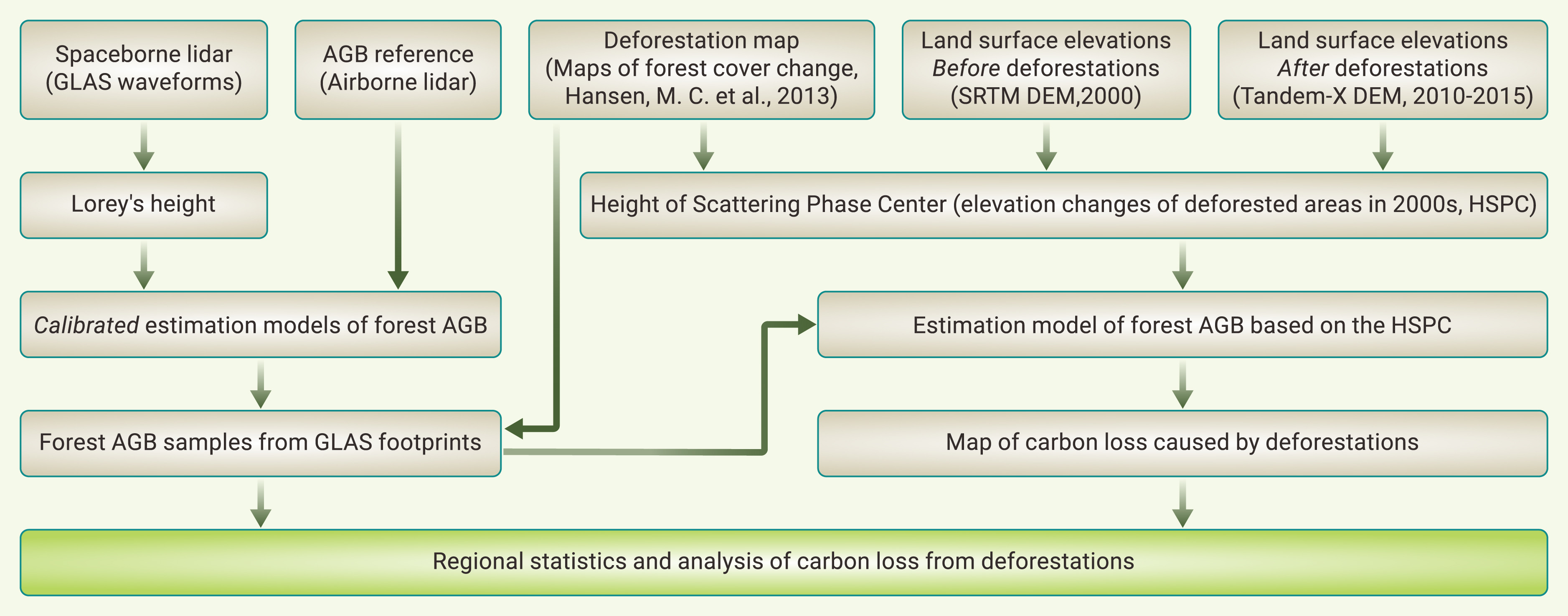
Figure 1.
Workflow for mapping the carbon loss in deforested areas
-
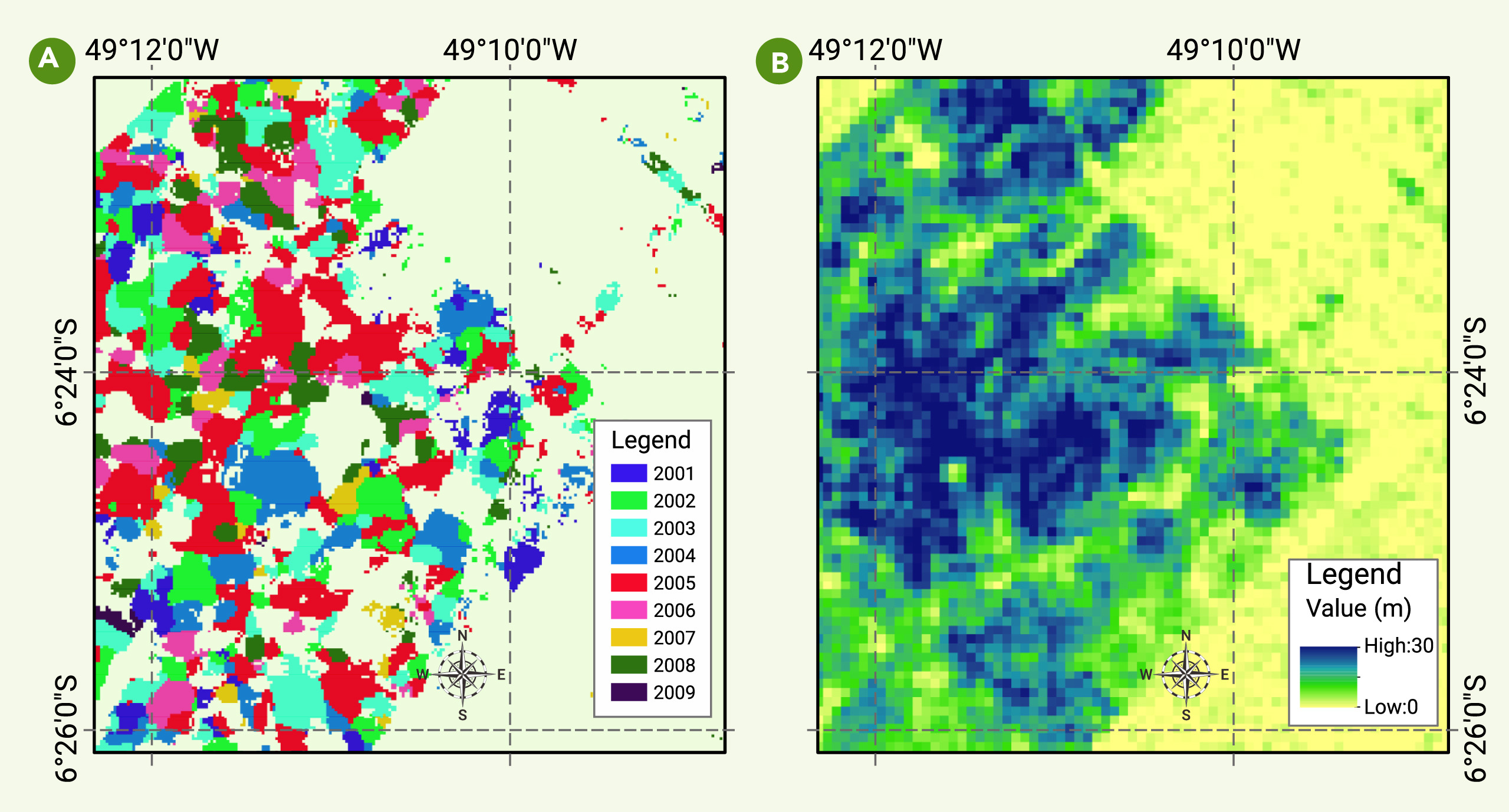
Figure 2.
Height of the scattering phase center of SRTM-DEM extracted in deforested areas
-
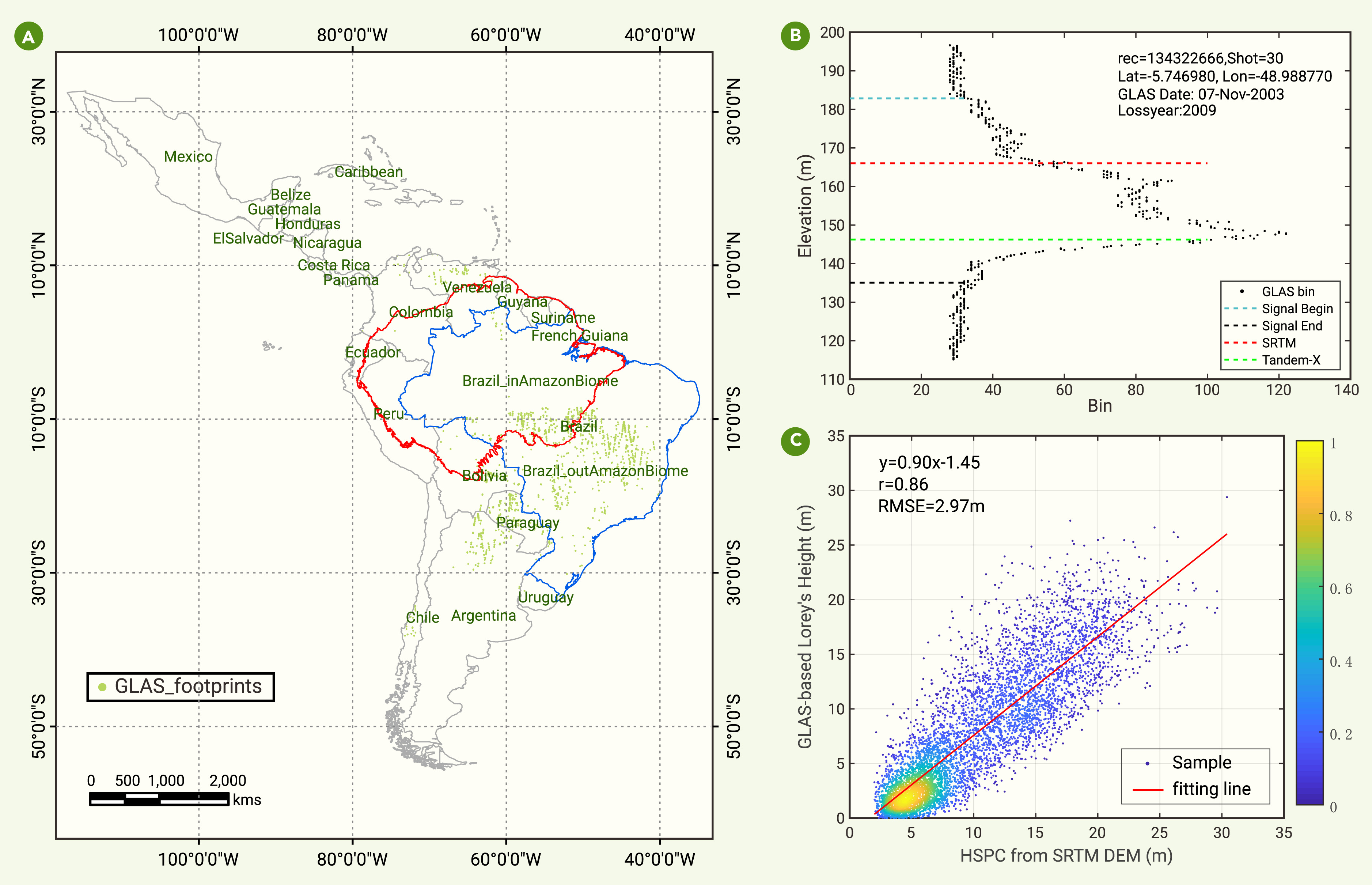
Figure 3.
Relationship between HSPC and LoreyH
-
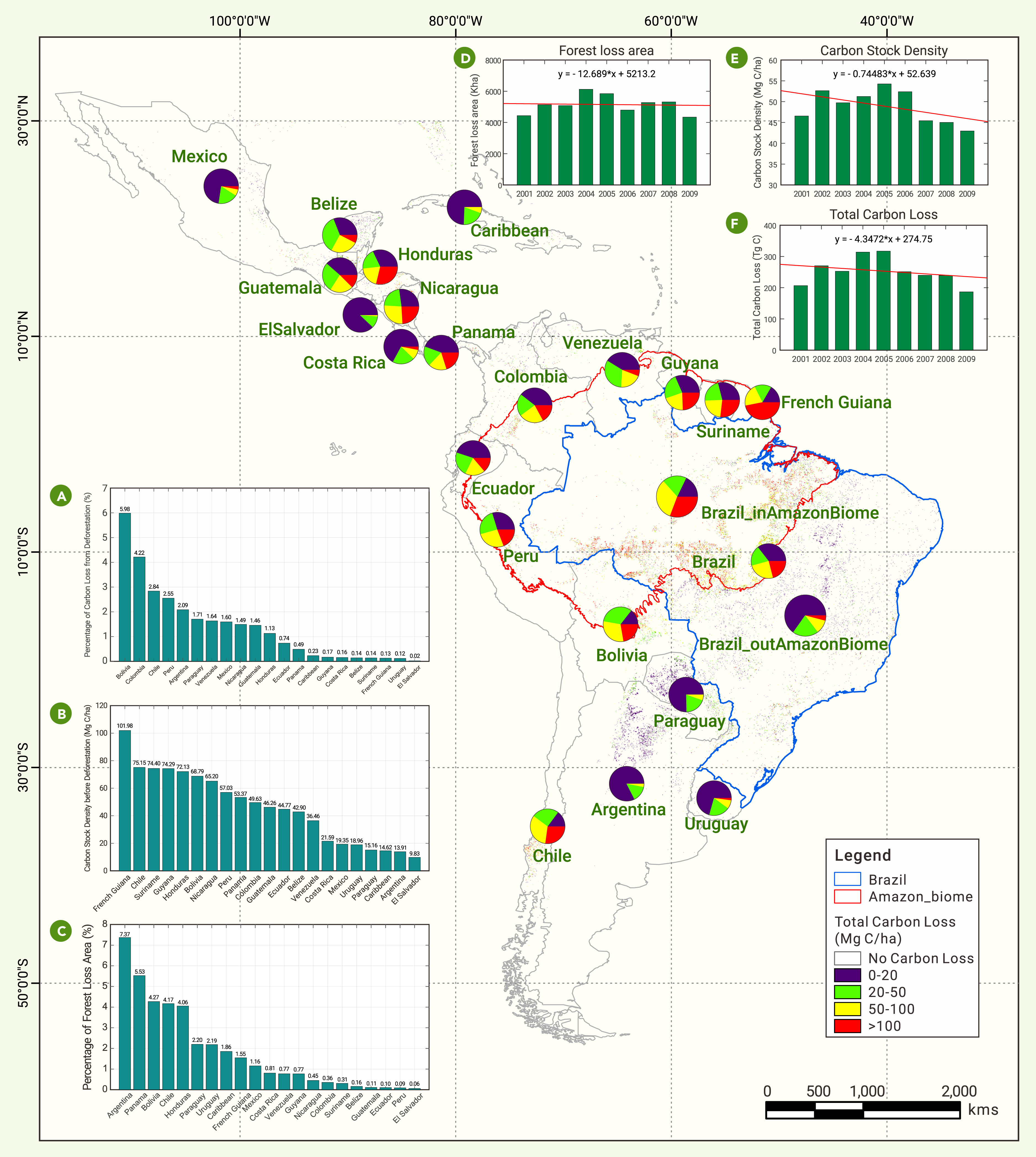
Figure 4.
Carbon stock density map of lost forests before deforestations and statistical analysis
-
Figure 5.
Carbon densities and relative loss contribution of countries
-
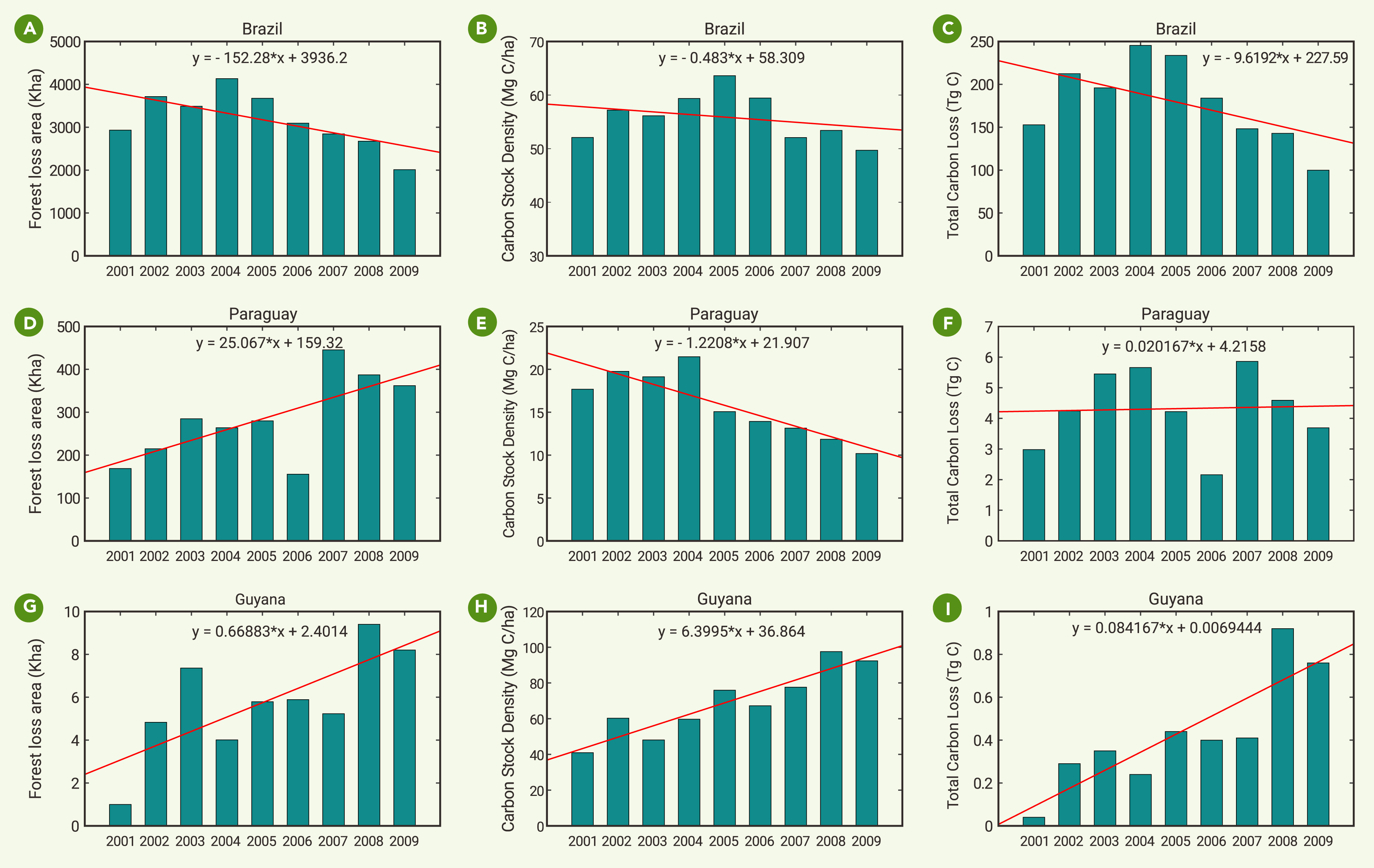
Figure 6.
Trends of deforestations of selected countries in the 2000s
-
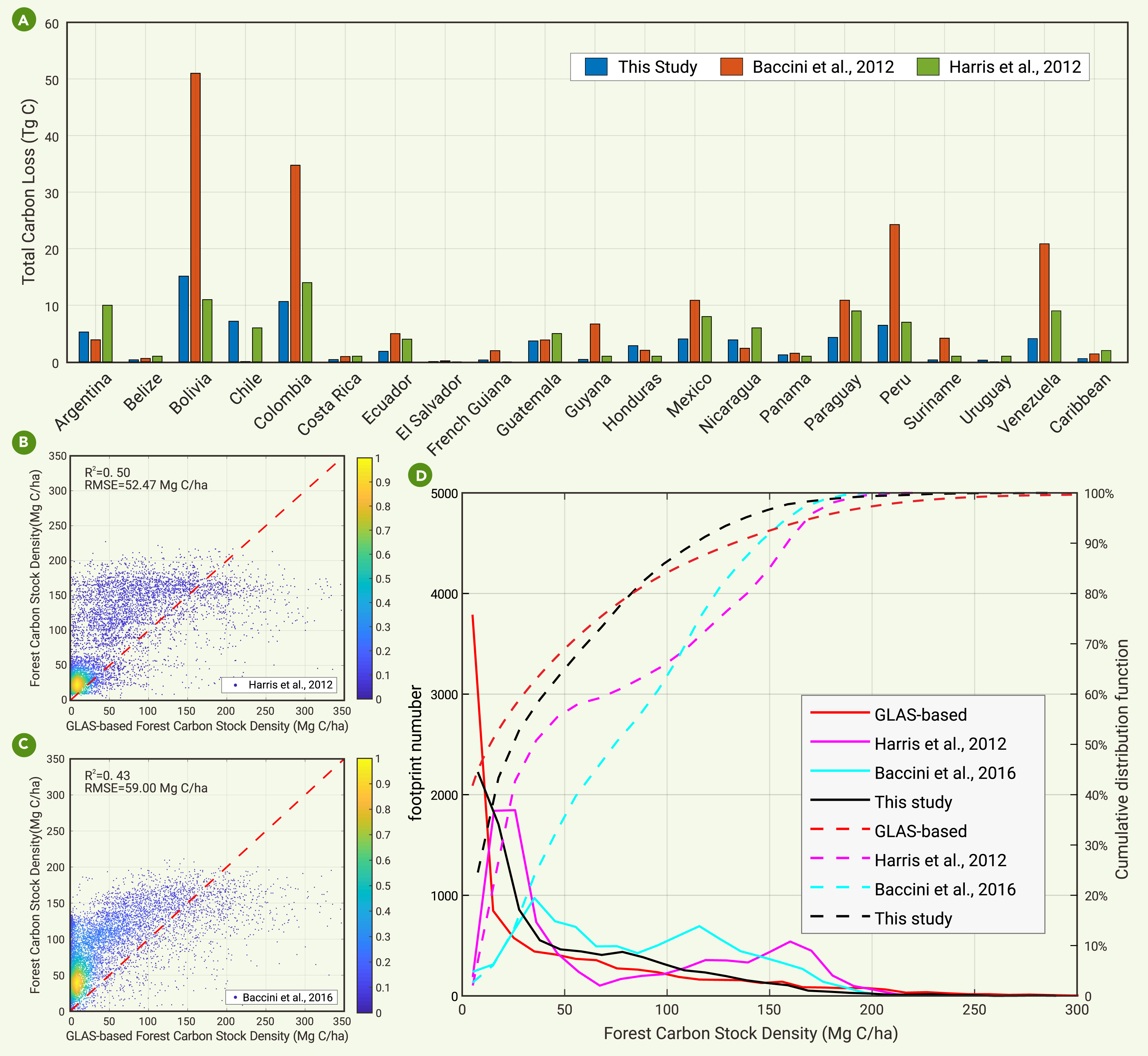
Figure 7.
Comparison of our results with those of existing studies
